
This solution is developed by:

Designing marine protected areas and spatial conservation measures is rarely straightforward. Closing fishing grounds to protect vulnerable marine ecosystems, sensitive habitats, or threatened species can have significant consequences for fishing fleets, coastal communities, and the economic viability of fisheries. Without robust tools to anticipate these consequences, spatial management decisions risk creating conflicts between conservation objectives and the livelihoods that depend on the sea.
DISPLACE, a dynamic, individual-based model for spatial fishing planning and effort displacement, provides fisheries managers, scientists, and policymakers with the capacity to simulate how fishing fleets respond to spatial restrictions, and to quantify the ecological and socioeconomic trade-offs involved. Within MarineGuardian, DISPLACE is used to evaluate the fleet-scale impacts of the project’s solutions and to support evidence-based spatial management in the project’s case study areas.
The challenge
Spatial fisheries management, including the designation of marine protected areas, the closure of vulnerable marine ecosystems to bottom fishing, and the development of offshore wind farms, directly affects where and how fishing fleets operate. Evaluating these impacts requires:
- Fleet-scale spatial data on vessel movements, effort distribution, and landing patterns
- The ability to simulate effort displacement which is how fleets redistribute when access to certain areas is restricted
- Integration of ecological and economic dimensions, capturing both the conservation benefits and the costs to fishing communities
- Scenario testing capacity, allowing managers to compare multiple policy options before implementation
These requirements go beyond what static assessments can deliver. They demand dynamic, spatially explicit modelling tools capable of operating at the scale of individual vessels and entire fleets simultaneously.
The solution
DISPLACE is a dynamic, spatially explicit, individual-based model that simulates the behaviour of fishing fleets under different spatial management scenarios. Originally developed at DTU Aqua and documented in the Canadian Journal of Fisheries and Aquatic Sciences (2014), DISPLACE has since been applied in scientific advice and policy contexts across European and international fisheries.
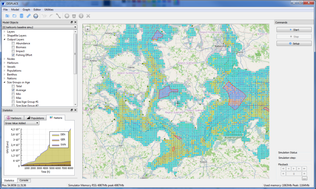
Within MarineGuardian, DISPLACE is used to:
- Scale individual solutions to the whole fleet, estimating the catch, fuel savings, and bycatch reduction achievable under different implementation scenarios
- Simulate spatial management scenarios, including real-time closures, vulnerable marine ecosystem protections, and interactions with offshore wind farm development
- Evaluate effort displacement, tracking how fleets redistribute spatially when areas are closed or restricted
- Quantify ecological and economic trade-offs for each scenario versus a business-as-usual baseline, using metrics including:
- Fuel-use intensity (litres per kg landed)
- Catch rate (kg per unit effort) and break-even effort
- Bycatch rate (kg per unit effort)
- Area swept per kg landed
Case study applications within MarineGuardian:
- Bay of Biscay: fleet-scale simulation of MarineGuardian solutions, integrating VMS and logbook data received via ICES
- West of Scotland: comparison of the SmartTrawl solution against baseline selectivity, including cod recovery dynamics and offshore wind farm interactions
Development and progress
Conditioning DISPLACE within MarineGuardian follows a structured data collection and modelling pipeline. Significant progress has been made on assembling the core spatial and effort datasets: fishing effort density maps combining VMS and logbook data have been obtained via ICES, landing port locations and vessel numbers are confirmed, and fisheries-related RDBES data has been received. Data treatment at the individual vessel scale across different harbours and fishing activities is currently ongoing. However, several key inputs remain pending, including fish stock distribution maps, stock assessment data, bycatch species distribution maps, and scenario spatial layers. DISPLACE simulations have not yet started.
Next steps focus on finalising the data collection questionnaire in coordination with the broader socioeconomic tasks, collecting the remaining biological and spatial data inputs from partners, and conditioning and running DISPLACE simulations for the Bay of Biscay and West of Scotland case studies. Fuel reduction scenario analyses, drawing on findings from the economic viability assessment, are also planned for integration into the modelling framework.
Expected impact
Within MarineGuardian, DISPLACE is expected to contribute to:
- Evidence-based spatial management, providing quantitative support for decisions on area closures, MPA design, and conservation measures affecting fishing fleets.
- Fleet-scale quantification of MarineGuardian solution benefits, translating gear and technology improvements into ecologically and economically meaningful outcomes at the fishery level.
- Reduced conflict between conservation and fishing interests, by making the socioeconomic consequences of spatial restrictions transparent and comparable across scenarios.
- Support for regulatory compliance and policy development, including alignment with EU obligations on VME protection and ecosystem-based fisheries management.
