
This solution is developed by:

Bycatch (the incidental capture of non-target species) remains one of the most pressing environmental challenges facing commercial fisheries. In the Bay of Biscay and Iberian Waters, demersal trawl fleets regularly interact with protected and endangered taxa (PET species), including common dolphins, seabirds, and elasmobranchs. Reducing these interactions requires practical, accessible tools that bring spatial risk information directly to the people making operational decisions at sea.
The Bycatch Risk Maps tool provides fishers and fleet managers with an interactive, user-friendly application displaying the areas of highest bycatch probability and species encounter rates — enabling proactive avoidance of high-risk zones before gear is set.
The challenge
Anticipating where bycatch events are most likely to occur requires integrating large volumes of biological, environmental, and fisheries data across species, seasons, and fishing grounds. Without accessible and easy-to-interpret tools, this information rarely reaches fishers in a usable form.
Current approaches to bycatch risk assessment are often:
- Fragmented, with observer data, catch records, and environmental datasets held separately and rarely combined.
- Inaccessible to end users, as outputs are typically produced for scientific or regulatory audiences rather than operational fishing crews.
- Static, failing to reflect the dynamic nature of species distributions across seasons and environmental conditions.
The solution
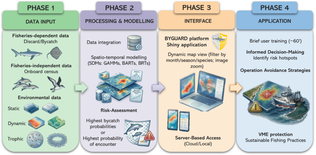
The Bycatch Risk Maps tool, developed as an interactive Shiny application, addresses these gaps by translating complex, multi-source data into an intuitive spatial platform requiring no additional hardware from its users.
The tool works by:
- Integrating fisheries-dependent data (observer records and catch data) to identify areas with historically high bycatch rates
- Incorporating fisheries-independent data (scientific surveys and environmental datasets) to map species encounter probabilities
- Covering multiple taxa simultaneously, with a focus on common dolphins, seabirds, and elasmobranchs
- Operating across different temporal scales, allowing users to consult risk maps by season or shorter time windows, reflecting changes in species distribution and fishing activity
- Combining static and dynamic environmental variables alongside trophic data to improve the accuracy and relevance of predictions
The primary target is the demersal trawl fleet of the Bay of Biscay, with planned extension to longline, purse seine, and small-scale fisheries as data availability allows.
Development and progress
The tool has been advanced in the last year by compiling fisheries-dependent and independent data as well as dynamic and static environmental data and trophic data. A preliminary selection of species suitable for modelling has been completed.
For the next 6 months the plan is:
- Data integration across all compiled sources into a unified modelling framework
- Spatio-temporal modelling: development and calibration of Species Distribution Models (SDMs), including Generalised Additive Mixed Models (GAMMs), Bayesian Additive Regression Trees (BARTs), and Boosted Regression Trees (BRTs)
- Preliminary risk mapping: identification of areas with the highest bycatch probabilities and species encounter rates
- BYGUARD platform conception: architectural design and initial development of the Shiny application interface
Expected impact
The Bycatch Risk Maps tool is expected to contribute to:
- Reduced bycatch of PET species (common dolphins, seabirds, and elasmobranchs) through proactive, data-driven spatial avoidance
- Highly accessible decision support for local fleets, delivered through an intuitive platform with no extra hardware requirements
- Improved regulatory compliance, bridging the operational gap between fishing practice and EU and international conservation obligations for endangered and protected species
- Long-term ecological monitoring, with bycatch reduction rates tracked across the Bay of Biscay and Iberian Waters region
How impact will be measured:
- Documented feedback from target users in the Basque Country fishing community
- Long-term tracking of sensitive species bycatch rates across the demersal trawl fleet in the Bay of Biscay and Iberian Waters region
